The 6,902 hectare Hailstone Property is comprised of 8 contiguous claims that are part of the Trident’s broader Greywacke Lake Gold Property. The Property is located in northern Saskatchewan, approximately 100 km northeast of La Ronge, and is road-accessible via Highway 102 that runs through the center of the Property to provide year-round access. Trident has also staked additional claims immediately adjacent to both Hailstone and Greywacke that host multiple base and precious metal showings.
The Hailstone Property has been the focus of several historical exploration programs, primarily completed in the late 1980’s and early 1990’s, that have identified several gold and copper showings including:
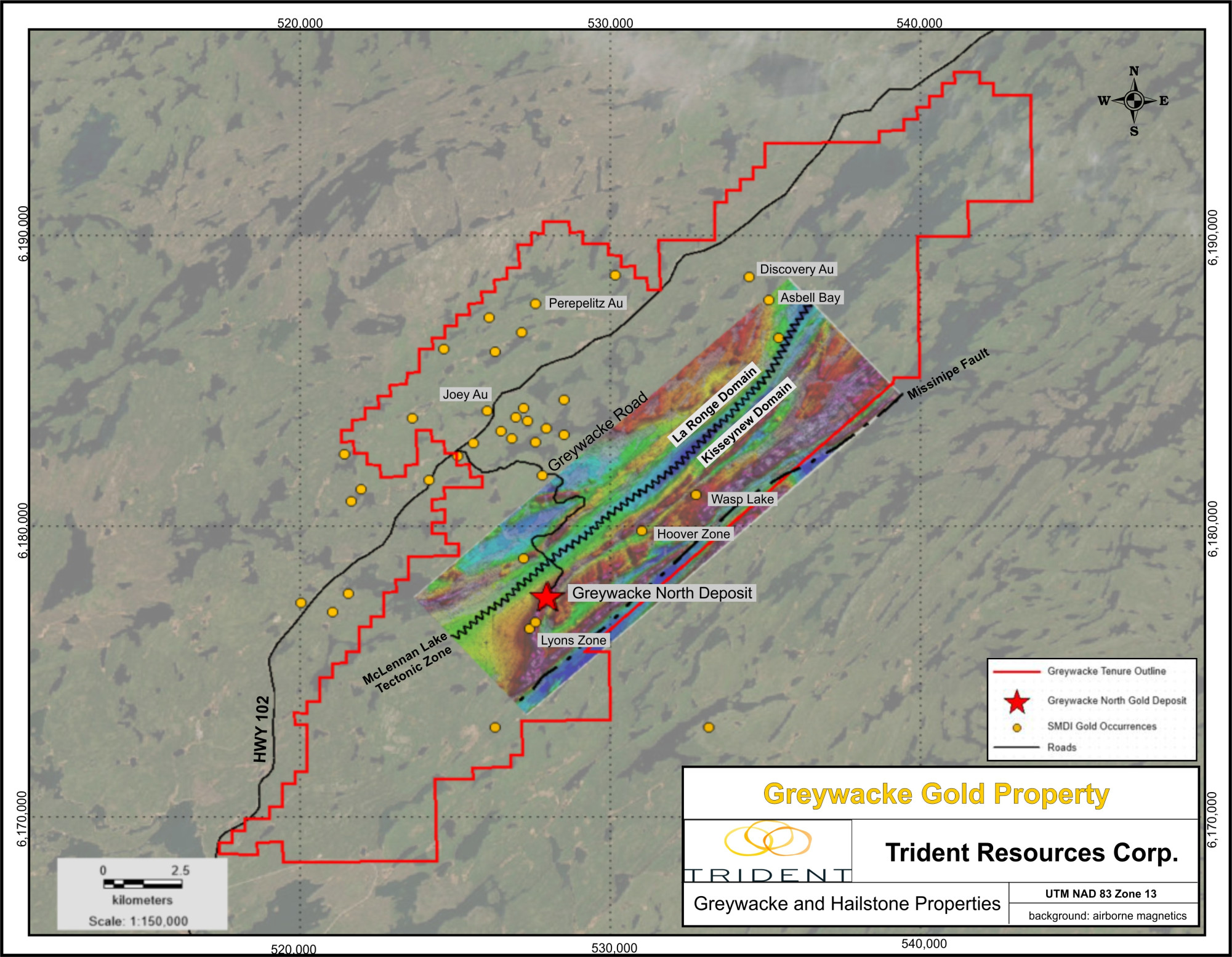
Asbell Bay: Grab samples that returned 3.19, 6.1 and 15.9 g/t Au and up to 6.3% Cu from shear zones with quartz veining
Cameco Quartz Vein: Grab sample returned up to 101.81 g/t Au
Perepelitz-Cockwill Lake: Multiple rock surface samples that range from 1.03 g/t to 12.92 g/t Au and 0.63% to 4.3% Cu
Joey Gold Showing: The Joey gold showing (SMDI 2421) is located on mineral disposition MC00019349, which is 100% owned by Trident Resources Corp. The showing area is underlain by the northeast trending Central Metavolcanic Belt (CMVB) within the La Ronge Domain of the La Ronge Gold Belt. The felsic to intermediate intrusive and volcanic rocks of the CMVB have been intruded by the composite granodioritic Berven Lake pluton.
Discovered in 1987 during a regional prospecting program near Berven Lake, the Joey gold showing consists of pyrite and gold hosted in rusty, vuggy quartz veins within a shear zone that trends northeast (045 º) and dips at a shallow angle (14º) toward the northwest. In the showing area, additional pyrite mineralization has been documented in southeast (120º) trending quartz veins that are thought to be hosted in conjugate faults that are related to the main northeast trending structural fabric. A major ENE (065º) trending shear zone appears to disrupt and offset the mineralized quartz veins.
Select chip samples from the Joey showing were reported to assay between 1.92 to 6.92 g/t Au over distances from 50 to 90 centimeters (from Saskatchewan Mineral Deposit Index). In 1988, eight shallow drillholes (Assessment File 73P16-0084) that tested the Joey showing returned anomalous gold values including:
- Drillhole BR8-5 intersected a pyrite-chalcopyrite-magnetite breccia that returned 0.908 oz/ton Au (31.13 g/t) over 1.0m between 10.1 and 11.1m
- Drillhole BR8-7 intersected a chlorite-rich fault zone that returned 0.349 oz/ton Au (11.96 g/t) over 1.5m between 54.4 and 55.9m. Also in the same hole, a bleached granodiorite returned 0.170 oz/ton Au (5.83 g/t) over 1.5m between 76.2 and 77.7m
More recently in 2020 and 2021, exploration programs focused on the Asbell Bay area completed airborne drone-based magnetic surveys and an IP-Resistivity survey that was followed up with eight shallow drillholes for a total of 908 meters. The most successful of the drillholes targeted a northeast trending resistivity high that encountered eight intervals that returned assay values in excess of 100 ppb Au (high of 783 ppb Au and 3700 ppm Cu). The Property hosts numerous documented base and precious metal showings that have not yet been properly tested with systematic surface sampling and geological mapping.
In 2025, Trident Resources Corp. has recently staked adjacent claims that host multiple gold showings that extend the mineralized trends identified on the Hailstone Property. Trident intends to investigate all of these underexplored showings with ground-based surface sampling and prospecting programs that will seek to assimilate the available data within a regional framework.
Gold Deposits and Past-Producing Mines Located Near the Hailstone Property:
Bingo/Roy Lloyd Mine: Past-producer of 25,748 oz Au with an indicated resource of 82,817 oz Au (currently owned by Golden Band Resources)
Jasper Mine: Past-producer of 82,697 oz Au (currently owned by Wescan Goldfields)
Star Lake Mine: Past-producer of 76,900 oz Au (currently owned by Golden Band Resources)
Jolu Mine: Past-producer of 203,301 oz Au with an operational 450 tonne/day mill, a tailings management facility, assay laboratory and full camp (currently owned by Golden Band Resources)
Geological Setting:
Located in the La Ronge Domain of the Reindeer Zone within the Trans-Hudson Orogen, the Property straddles the contact between metavolcanic rocks to the NW and granitic intrusions to the SE. This package of rocks are part of the Central Metavolcanic Belt of the La Ronge Domain, which hosts multiple base and precious metal deposits, showing and past-producing mines.
The structural history of the La Ronge Domain is complex with several generations of deformation affecting the rocks and overprinting past events. The early D1 & D2 deformation events are thought to form the dominant northeast trending structural grain evident throughout the region. These early fabrics have been overprinted by open to closed north-trending and steeply east-dipping D3 folds and upright, northeast-trending D4 folds. High strain zones such as the McLennan Lake Tectonic Zone form northeast trending regional-scale bounding zones that contain complex interbranching networks of shears that often host gold mineralization. The metamorphic grade of the La Ronge Domain ranges from upper greenschist to lower amphibolite, which is slightly lower than the flanking metasedimentary belts.
Hailstone Project